
First release of 2017 for MapStore 2 plus WFS Support
Dear Readers,
we are pleased to announce a new release of MapStore 2, our flagship Open Source webgis product, which we have called 2017.01.00.
The full list of changes for this release can be found here, but let us now concentrate on the latest most interesting additions.
WFS Query on vector layers
We have introduced the option to query vector layers via the OGC WFS protocol. This functionality can be accessed from the Layer TOC (Table Of Content) once a layer that which advertise the OGC WFS procotols is added from the OGC CSW catalog widget.

Adding a layer from the Catalog
If a layer in the TOC supports querying via OGC WFS protocol a magnifier icon under the “Display legend and tools” will appear as shown below.

Magnifier Icon for WFS Query
A click on the icon will open a form, where you can choose to filter by attribute, spatially or both. Filters can be setup to match any, all or none of the specified conditions and complex queries with subfilters can be created.

WFS Query Builder
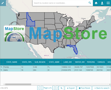
If the query is successful the first page of the results will be downloaded and put in a grid widget; such widget supports usual features like zoom to row, column selection and export as CSV (more formats will be added in the future).

Results of a WFS query

Exporting WFS results as CSV
Standalone binary package
We have created a downloadable standalone package for you to test MapStore2 on your own machine. It is Windows and Linux compatible and it contains all you need to run MapStore 2, no installation required. All you have to do is:
- unzip to a location on your computer
- run the .bat command if on Windows or the
Please refer to the online documentation for further informations.
Developer notes
NPM 2 support has been dropped, MapStore2 now support:
- NodeJS >= 4.6.1
- NPM >= 3.x
What we are working on
We have a number of functionalities in our plans (editing, advanced templating, OAUTH 2.0, etc…); for the next release we are focusing on the following ones:
- Balloon Tutorial, for a more modern help system. More information can be found here
- Improved Developers Documentation
- Https support so that we use geolocation on Chrome as well
- Side effect management with redux-observable (for developers)
- Advanced Theming, which should allow us to easily change themes using an high level language like Less
If you are interested in learning about how we can help you achieving your goals with open source products like GeoServer, Mapstore, GeoNode and GeoNetwork through our Enterprise Support Services and GeoServer Deployment Warranty offerings, feel free to contact us!
