
New release of MapStore with improved map embedding
Dear Reader,
we are pleased to announce a new release of MapStore 2, our flagship Open Source webgis product, which we have called 2017.03.00. The full list of changes for this release can be found here, but the latest most interesting additions are the following.
- Improved Embed view
- Full Screen option
- Elevation Slider
Improved Embed view
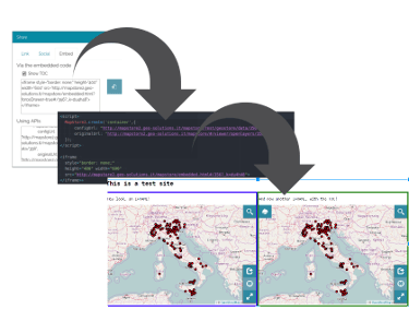
This release gives you more options when embedding a map. You can now choose to embed with an IFrame or by using the new MapStore2 Javascript API. The share tool now provides the two options with the code you can copy and paste in your site.

Share window now has more options
For the iFrame version you can choose if you want the table of content by checking the “Show TOC” option. For the API version, you have a full html page with the proper inclusion of css and javascript files.
Table of Content is optional inside IFrame
The table of content on the left side is now hidden by default so your users can focus on your data and have more room to view it. If you still want to display the TOC, you can add the “forceDrawer=true” parameter in the URL. Here is the result:

Iframe with and without TOC
Here a real map included.
Page with API
In certain environments you really do not want to use an iFrame, but you would rather want to integrate the map as part of your application using a JavaScript API: you can now do it with the newly created MapStore2 API. The Share window will now generate the html you can put in your page and leverage the MapStore2 API to load and configure the map. Here is how it looks like:

A possible usage of the JS API in your page
You can also programmatically interact with the map using the Javascript API, listening for events. You can learn what you can do with the JavaScript API by following the reference here. You can find a sample application that uses the Javascript API here.
Full Screen Supoport
The map can now be expanded to full screen size.

Fullscreen switch
This is very useful for small devices where the screen space is small.
Initial support for Elevation Dimension on WMS
MapStore now detects if a layer has an elevation dimension and displays a new tab in the layer properties window. From the new tab you can choose the elevation to display.

Elevation Slider in action
In the example you can see the values of the elevation/depth provided by the server in a chart. This widget guides the visualization by setting the values of the Elevation dimension for the layeryou are viewing.
Future Work
In the next release we will focus on bug fixes as well as user interface improvements, including also a fully integrated 3D Viewer for maps based on Cesium.


Stay tuned for more news on this blog as well as on the mailing lists.
If you are interested in learning about how we can help you achieving your goals with open source products like GeoServer, Mapstore, GeoNode and GeoNetwork through our Enterprise Support Services and GeoServer Deployment Warranty offerings, feel free to contact us!
The GeoSolutions team,
